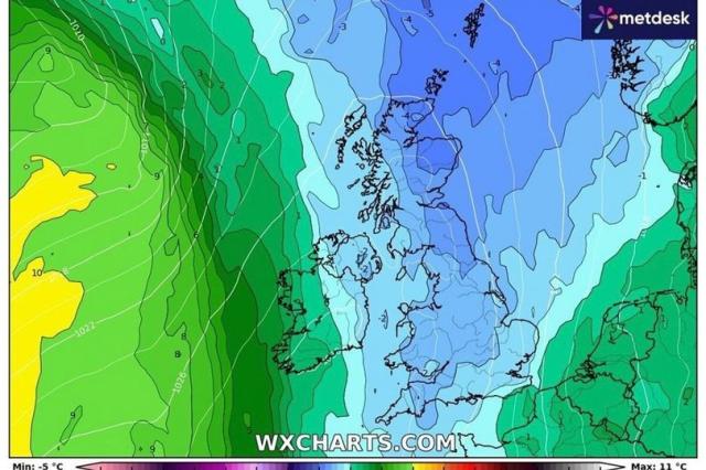
UK weather: Arctic blast set to hit as temperatures plummet to -4C next week, Met Office forecast
The United Kingdom is set to face an Arctic blast next week, with temperatures expected to plunge as low as -4°C in some regions. According to the Met Office, the cold snap will bring frosty mornings, icy winds, and the possibility of wintry showers, especially in northern and rural areas. As the nation gears up for the winter season, this sudden dip in temperature marks a sharp shift from the mild autumn conditions many have experienced recently.
What’s Behind the Arctic Blast?
The upcoming cold front is being driven by Arctic air masses sweeping down from the north. This weather system will push across the UK, dragging temperatures well below the seasonal average. Typically, November sees temperatures hovering between 6°C and 10°C, but this Arctic blast will bring much colder conditions.
Met Office meteorologist Alex Burkill explains: “Cold air from the Arctic will move down across the country, bringing a significant drop in temperatures. Some places could see temperatures fall to as low as -4°C, particularly in northern and rural areas. Frost is likely, and there’s even the possibility of some wintry showers.”
This sudden weather shift is due to a high-pressure system building over Greenland, which forces cold air to flow southwards. While the cold spell will be felt nationwide, areas in Scotland, northern England, and higher elevations are expected to bear the brunt of the chilly conditions.
How Cold Will It Get?
The most significant drop in temperature is expected overnight, with rural and northern areas experiencing lows of -4°C. In more built-up urban areas, temperatures are likely to hover between 1°C and 3°C, but the chill will still be noticeable. Daytime highs across much of the country will struggle to reach double digits, with most regions seeing highs of just 4°C to 8°C.
This cold snap is expected to last for several days, with the possibility of widespread frost and icy conditions in the mornings. The Met Office has advised motorists to be cautious, especially during the early hours, as frost and potentially icy patches on roads could make travel more hazardous.
Wintry Showers and Strong Winds
Along with the cold, some regions could also see wintry showers. While widespread snowfall is not currently in the forecast, the combination of cold temperatures and moisture in the air could result in sleet or snow in higher areas, particularly in Scotland and northern England.
Winds are also expected to pick up, adding to the chill factor. Strong northerly winds will make it feel even colder than the forecast temperatures suggest, with gusts likely in coastal areas and high ground.
Preparing for the Cold
As the Arctic blast approaches, experts are urging people to prepare for the colder weather. Homes should be insulated to keep the heat in, and vulnerable individuals, such as the elderly, should take extra precautions to stay warm. The Met Office is also advising people to check on neighbors, friends, and relatives who may be more susceptible to the cold.
With the arrival of this cold snap, the UK is seeing the first signs of the winter months ahead. While the chilly conditions are expected to ease after a few days, this Arctic blast serves as a reminder that winter is just around the corner, and residents should be prepared for more cold weather in the coming weeks.
In summary, the UK is bracing for an Arctic blast next week that will bring freezing temperatures, frosty mornings, and the possibility of wintry showers. The Met Office advises taking precautions, especially on icy roads, and preparing for a cold start to winter.
Leave a Reply