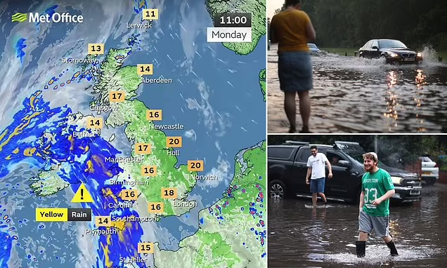
This week, the United Kingdom is set to experience a remarkable contrast in weather conditions. While some regions will bask in warm, sunny weather, with temperatures reaching up to 25°C, others will be battered by heavy rainfall, potentially equivalent to nearly an average month’s worth of precipitation in just two hours.
Sunshine for Some
For those lucky enough to be in the right parts of the country, this week promises to deliver what might feel like a brief summer resurgence. After a season marked by unpredictable and often disappointing weather, areas in the south and southeast of England are expected to enjoy glorious sunshine. Temperatures could climb to a balmy 25°C, providing a perfect opportunity for outdoor activities, from picnics in the park to beach outings.
Forecasters suggest that the warm weather will be most prominent in London, the Home Counties, and parts of East Anglia. The high pressure system responsible for this warm spell is expected to linger for several days, giving these regions a pleasant respite from the cooler, wetter conditions that have dominated much of the summer.
A Deluge for Others
However, it won’t be sunshine and blue skies for everyone. In stark contrast to the warmth enjoyed by the south, parts of northern England, Scotland, and Wales are bracing for a deluge. Forecasters have issued warnings for heavy rainfall, which could bring almost a month’s worth of rain in just two hours. The Met Office has placed these regions on alert, cautioning residents about the potential for localized flooding, particularly in areas with already saturated ground.
The downpours are expected to be most intense in the northwest of England and parts of Scotland, where the weather system driving the rain will be at its most powerful. Rivers could swell rapidly, and flash flooding may occur in vulnerable areas. Emergency services are on standby, and residents are being advised to stay vigilant, especially those living near rivers and low-lying areas.
The Cause of the Contrast
This dramatic difference in weather conditions across the UK can be attributed to a split in the jet stream, which is currently positioned over the country. The jet stream, a fast-flowing air current high in the atmosphere, typically drives the weather patterns we experience. At present, it is directing warm, stable air toward the south while steering cooler, unstable air laden with moisture toward the north.
Meteorologists explain that this kind of split in the jet stream is not uncommon, but the stark difference in weather it creates is certainly notable. The southern half of the UK benefits from the high-pressure system, which brings clear skies and warmth, while the north is left to deal with the low-pressure system, which brings clouds and rain.

What to Expect
The stark divide in weather conditions means that people across the UK should prepare for very different experiences this week. In the south, it’s time to make the most of the late summer sunshine, with temperatures that are perfect for enjoying the outdoors. However, in the north, it’s crucial to be prepared for potentially severe weather.
Those in affected areas should monitor weather updates closely, secure their properties against possible flooding, and avoid unnecessary travel during the worst of the rain. The Met Office will continue to update its warnings as the situation develops.
As the week progresses, the contrast between the two halves of the country will be a striking reminder of the unpredictable nature of British weather. Whether enjoying the sunshine or preparing for a downpour, it’s clear that this week will be one to remember for weather enthusiasts across the UK.
Leave a Reply